


Air Navigation Pro


Описание на Air Navigation Pro
Открийте нашето приложение за планиране на полети и навигация в реално време безплатно за 28 дни!
- Всичко, от което се нуждаете, за да летите по света
- Планирайте полета си за няколко минути
- Летете спокойно с актуална информация
Air Navigation Pro е висококачествено приложение за асистент за пилоти от цял свят. Възползвайте се от следните основни характеристики:
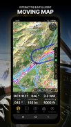
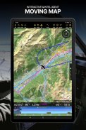
ДВИЖЕЩА СЕ КАРТА
Планирайте и навигирайте с помощта на нашата интерактивна движеща се карта. Изберете между аеронавигационни карти, сателит или нашата векторна карта като фон. На всичкото отгоре подвижната карта показва пътни точки, NOTAM, препятствия и въздушни пространства от нашата изчерпателна, винаги актуална световна аеронавигационна база данни. Докоснете произволна точка директно върху картата, за да създадете лесно маршрут. Персонализирайте стойностите, показани в лентата за навигация, за да имате точно информацията, от която се нуждаете: надморска височина, вертикална скорост, пеленг, разстояние до следващата точка, изчисления на ETA и т.н. Изберете процедурите за заминаване и пристигане на летището за вашия маршрут, за да ги показвате и отгоре на движещата се карта.
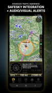
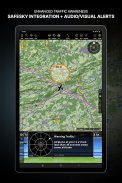
ПОДОБРЕНА ИНФОРМАЦИЯ ЗА ТРАФИКА
Получавайте визуални и аудио сигнали на всички езици за конфликтен трафик наблизо. Изберете предпочитаната от вас икона за трафик между общи, самолетни или TCAS символи. Вашата безопасност е важна за нас, поради което си партнирахме със SafeSky, за да гарантираме, че нашите потребители разполагат с данни за трафика на живо по време на своя полет. Възползвайте се от естествената интеграция със SafeSky, включена в новите ни абонаменти Smart Lite, Smart Classic и Smart Advanced — пакет две в едно!
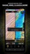
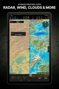
РАЗШИРЕНИ МЕТЕОРОЛОГИЧНИ СЛОЕВЕ
В допълнение към основните метеорологични доклади за ветрове и TAF/METAR за вашия полет, абонатите на плана Smart Advanced могат да активират прозрачни метеорологични слоеве върху движещата се карта. Наличните слоеве включват радар за дъжд, вятър, налягане, облаци и дъжд, видимост, пориви и допълнително за Германия, Швейцария, Австрия и Балканите, съобщава GAFOR. Докоснете която и да е точка на картата, за да видите информацията за времето за тази област. Прегледайте прогнозата за времето до три дни напред.
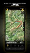
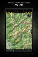
NOTAM
След като създадете своя маршрут, задайте час на тръгване в бъдеще, за да може движещата се карта да показва NOTAM, активен за това конкретно време. NOTAM на картата променят цвета си динамично въз основа на техния статус.
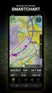
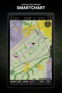
SMARTCHART
Нашата авангардна SmartChart е изключително подробна и интелигентна векторно-базирана карта, която се адаптира към вашите нужди, предоставяйки ви адекватна информация при всяко ниво на мащабиране. SmartChart оптимизира показването на сенки за лесно разграничаване между долини и планини, а текстът остава идеално подравнен, гарантирайки оптимална четливост. Включително последните значителни подобрения с гори и подробна информация за летището.
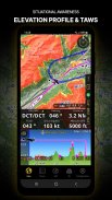
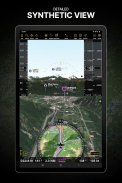
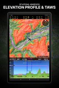
ВИСОЧЕН ПРОФИЛ И СИНТЕТИЧЕН ИЗГЛЕД
Активирайте изгледа на профила под навигационната лента за подобрена ситуационна осведоменост за надморската височина пред вас или по маршрута ви. Изберете ширината на коридора между 0 до 5 NM и опции за наслагване: въздушни пространства, NOTAM, препятствия, компоненти на вятъра, населени места и т.н. Превключете към синтетичен изглед за допълнителна информация за терена, плюс изкуствен хоризонт с индикатори за височина и вертикална скорост. Тази функция може да се използва и за панорамно придвижване, докато се подготвяте за полета си. Активирайте TAWS на движещата се карта, както и на синтетичния изглед.
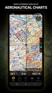
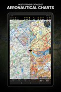
АЕРОНАВИГАЦИОННИ КАРТИ И КАРТИ ЗА ПОДХОД
Ние предлагаме най-обширния световен каталог от аеронавигационни карти, включително картите на ICAO. Нека географските диаграми за подход се показват в горната част на движещата се карта или синтетичния изглед.
БРИФИНГ
Подгответе полета си с нашия брифинг раздел, като създадете документи с NOTAM и метеорологични карти и станции, подходящи за вашия планиран маршрут. Оптимизирайте времето, като създадете профил на въздухоплавателното средство, който ще се използва в секцията Briefing за предварително попълване вместо вас на полетен план на ATC и изчисляване на W&B.
И МНОГО ОЩЕ!
Абонаментът ви позволява да използвате приложението на три устройства. Препоръчваме да създадете акаунт за въздушна навигация за подобрено управление на устройството. Обърнете се към нашето ръководство за потребителя на нашия уебсайт: www.airnavigation.aero за повече информация.
Air Navigation Pro - Version 8.4.5.505070725
(08-05-2025)

Air Navigation Pro - APK информация
APK версия: 8.4.5.505070725Пакет: com.xample.airnavigationLatest Version of Air Navigation Pro
Други версии


 3.98
3.98

Apps in the same category

You may also like...


